

Computer model will help evaluate impacts of pumping
-
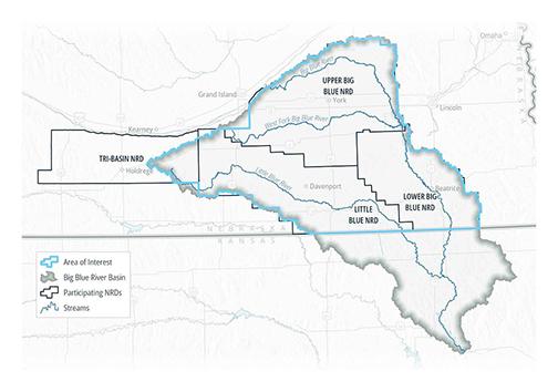 This graphic shows the area of interest for a recently completed computer model that will help local NRDs evaluate the impact of water pumping from the aquifer.
Editor’s note: With the recent proposal to build an ammonia plant near Aurora that will use a large amount of water each day and the agreement last month by city and county officials to participate in a groundwater sustainability study along with the Upper Big Blue Natural Resources District, the subject of groundwater usage is of high interest right now. Considering the amount of water needed by agriculture for irrigation and the possibility that the proposed Synergen Green Energy plant will attract other large water using industries to locate here, many are concerned about the sustainability of the aquifer which is greatly depended on in this area.
In view of these concerns and desiring to protect this important resource, the Upper Big Blue NRD recently completed a Regional Blue Basin groundwater computer model, which is now being used to evaluate possible water use impacts in the Upper Big Blue District and beyond.
The following article, provided by Upper Big Blue, describes the purpose of the computer model and how it will be used to protect our area’s ground water resource.
by Chrystal Houston
After several years of development, the Blue River Basin model is complete and is already being used to evaluate possible water use impacts in the Upper Big Blue Natural Resources District. Given the drought conditions in much of the district in the last growing season, this resource is especially timely as it will help the NRD board to “protect water supply for all beneficial purposes,” one of the 12 areas of responsibility shared by all NRDs and dictated by state statute.
The Upper Big Blue NRD has partnered with the Nebraska Department of Natural Resources and three other NRDs in the Blue River Basin in this ambitious modeling project. Since 2017, the group has been working with an engineering firm to conduct a comprehensive survey of the Blue River and tributaries to identify the extent to which they are hydrologically connected—where groundwater and surface water interact. The balance between surface water and groundwater is a vital data point to understanding the water system in the district.
The model will help the participating Natural Resources Districts (NRDs) and the Nebraska Department of Natural Resources (NeDNR) efficiently evaluate the potential impacts of current and future groundwater pumping on aquifer levels and stream flows.
By collecting information about stream flow, groundwater recharge, land use in the basin, drought patterns, and average rainfall and water use, engineers created a computer model that allows users to run scenarios to test different variables. While there are planned improvements to the model, including the addition of stream gauges at additional sites, the model is already providing useful results.
The model was recently utilized to determine the impact of a proposed fertilizer plant development in Hamilton County, which would be classified as a Large Water User. Such well permit applicants are required to complete a hydrologic evaluation to make sure that the water quantity in the area is sufficient to meet the needs of the business development without causing aquifer depletion that would prevent other existing users from accessing the water they need, including domestic and irrigation wells.
The model’s primary area of interest covers the entire Upper Big Blue, Lower Big Blue, and Little Blue NRDs as well as the Little Blue River Basin within the Tri-Basin NRD. The model also includes geographic areas around the perimeter of the NRDs (including areas in northern Kansas), but these perimeter areas are not modeled in detail.
The model was developed in part to estimate potential stream flow changes resulting from changes in aquifer levels and pumping, as well as to determine the appropriation status of different areas of the basin. Modeling in the Upper Big Blue Natural Resources District started in 2005 with an effort to produce a similar tool for the Platte River. At that time, the Nebraska Department of Natural Resources was looking for data about whether the Platte River basin (surface and ground water) was fully appropriated (meaning the balance of water use and water demand indicates that increased planning is needed) or over-appropriated. Part of the district between Phillips and the Platte River was deemed fully appropriated at that time based on the results of the modeling project. This outcome made apparent the value of groundwater modeling for planning and management.
When that study was complete, the focus shifted from the Platte River hydrologic interconnection to the Blue River. The newest model created relies on updated data and methodologies, reflecting the best available science, providing a more robust model.
The Blue River Basin Model has two main parts. The first part analyzes groundwater needs for agriculture, municipalities, and industries as well as the aquifer recharge, end-of-field runoff, and stream flow that results from these uses. The second part uses the data on groundwater needs to analyze the impacts of pumping on the aquifer and stream flow.
So, how accurate is the model and what are its limitations? The model was “calibrated” using available historical records of groundwater levels, pumping, and stream baseflows in the Blue River Basin from 1940 to 2017. The goal of calibration was not to precisely reproduce every aspect of the historical record – no model can accomplish that. However, the calibration results showed good overall matches with historical records on a regional basis.
The model focused on regional hydrologic processes and water management. To zoom in and see local-scale information, model refinement in the area of interest would be needed. Similarly, calibration results were better in some places than others. Additional data will be collected moving forward to improve model calibration.
Now that the model is completed, the data regarding hydrologic connection will become part of the NRD’s Voluntary Integrated Management Plan. Having this plan in place will allow the NRD to apply for additional funding through the Nebraska Water Sustainability Fund to make improvements in the district to reduce the threat to the water supply.
Chrystal Houston is public relations manager with the Upper Big Blue Natural Resources District.